Applications and Benefits of Geographic Information System (GIS) in Digital Campus Map: A Systematic Review
Keywords:
Geographic Information System, digital campus, mapAbstract
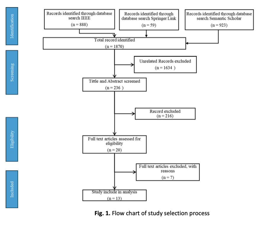
The integration of Geographic Information System (GIS) technology in the development of digital campus maps has emerged as a significant advancement in higher education institutions. GIS technology enables the visualization, analysis, and interpretation of spatial data, offering enhanced navigational and informational support for students, faculty, staff, and visitors. Key applications include real-time location tracking, detailed information of campus facilities, route optimization, and integration with other platform. A review of the literature was therefore carried out to the applications and benefits of GIS in creating digital campus maps as well as the technologies used in this development. The articles were selected from SpringerLink, the IEEE Xplore digital database and Semantic Scholar using the keywords ‘digital map’, ‘campus map’, ‘mobile application’ and ‘Geographic Information System (GIS)’ and a total of 1870 articles were obtained and screened from the referenced databases. Finally, a total of 15 publications were chosen to evaluate information after inclusion and exclusion criteria in order to accomplish the primary goals of this research. The benefits of implementing GIS in digital campus maps are manifold: it provides a unified user experience, ensures consistent and up-to-date information, improves accessibility, and enhances data security. From the review finding, majority of researchers have increasingly focused on creating digital campus maps to provide essential navigational and informational support, making it easier for students, faculty, and visitors to navigate and utilize campus resources efficiently. However, these functions often remain distributed across various platforms and systems rather than being centralized in a single interface. Centralizing digital campus map functions offers numerous benefits, including a unified user experience, consistent information, streamlined management, and enhanced data security. By leveraging GIS technology, educational institutions can provide a more efficient and effective means of campus navigation and resource utilization, ultimately improving the overall educational experience for students, faculty, staff, and visitors.